

Fremont County
IDGenWeb

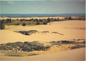 The black rocks in the foreground are basalt, a volcanic rock. The blue ridge in the
background is called the "Ashton Hill" and is actually the caldera of a huge
inactive volcano. Island Park is the area inside the old volcano and is fifty
miles across. The town of Island Park boasts of "the world's longest main
street." The opposite rim is at the Montana border and you would cross it at
Targhee Pass. Then its just a few miles down hill to West Yellowstone, Montana.
Yellowstone Park is made up of two equally huge, overlapping volcanoes. If any
of the three blows, the other two will go, and there will be lava all the way to
Pocatello. Geologists predict they will erupt sometime between today and 20,000
years from now.
The black rocks in the foreground are basalt, a volcanic rock. The blue ridge in the
background is called the "Ashton Hill" and is actually the caldera of a huge
inactive volcano. Island Park is the area inside the old volcano and is fifty
miles across. The town of Island Park boasts of "the world's longest main
street." The opposite rim is at the Montana border and you would cross it at
Targhee Pass. Then its just a few miles down hill to West Yellowstone, Montana.
Yellowstone Park is made up of two equally huge, overlapping volcanoes. If any
of the three blows, the other two will go, and there will be lava all the way to
Pocatello. Geologists predict they will erupt sometime between today and 20,000
years from now.
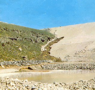
In Idaho for the Curious (Backeddy Books, Cambridge,
Idaho. 1982), p. 160f, Cort Conley claims these sand dunes are the highest sand
dunes in state, "perhaps the highest in the country, since they surpass those of
Death Valley . . . the dunes cover an area about thirty-five miles long and up
to five miles wide."
Fremont County has:
Railways valued at over $1,000,000.
Room for 150,000 more people.
Real estate valued at over $2,000,000.
Hundreds of streams which furnish good water power
and water for irrigation in inexhaustible quantity and convenient for various
canals.
A population of over 10,000 which is steadily growing.
Horses, sheep, cattle, hogs, and other live stock
valued at over $1,500,000.
Great ledges of fine building stone in all colors
of the rainbow.
Nearly 590 miles of canals with as many more contemplated.
Most farmers belong to stock companies and water costs not to exceed 25
cents per acre on the average.
The SILVER HAMMER, which is recognized as the best
weekly in Idaho, having a circulation exceeding 1,500 --sworn.
Mountains of iron and copper--not yet claimed.
Finest hunting and fishing in the west.
Ledges of gold and silver ores, which were not discovered
until last year. Some day in the near future Fremont County will take rank
second to none as a precious mineral producer.
The two forks of the Snake River and countless tributaries
(many un-named) furnishing water sufficient and of easy access to every
foot of land in Idaho, Oregon and Washington.
The finest and best body of coal (in Teton Basin)
that has ever been found west of Pennsylvania--fine for cooking purposes.
These mines now supply the local trade. Though but barely below the surface
the quality is far superior to the best produced at Rock Springs.
Many inviting mountain recluses.
Two of the best and most convenient routes to Yellowstone
National Park, on which it borders.
Vast grazing lands for cattle and sheep.
Over 50,000 acres under cultivation: over 200,000 under ditches.
Farms which produce as high as 60 bushels of wheat per acre.
Farmers who raise 6 tons of lucern--the great forage
plant of arid America--per acre.
Farms that produce over 400 bushels to the acre
of the finest potatoes in the world--excelling the Greeley, Colorado, product.
Strawberries of luscious flavor, and prodigious in
yield, raspberries, black berries, cherries, etc., excelled nowhere. The
hardier varieties of large fruits.
The honor of raising the largest head of grain in
the world--prize awarded at the World's Fair.
More premiums awarded to it for fine ranch products,
such as potatoes, cabbage, etc., at the Utah Territorial fair than any
county in Utah.
A healthful climate: fine mountain scenery--the
Teton range of mountains-- which are aptly styled the Alps of America,
the granduer of which must be seen to be appreciated.
A good, moral, industrious class of people, who
want more neighbors of the same kind.
A dozen saw mills, as many cheese factories, flouring
mills, with a combined capacity of 200 barrels per day, and several other
industrial enterprises.
The headquarters of the Bannock Stake of Zion, Rexburg,
where good schools, churches, fairs, etc., abound.
Several brass bands and musical organizations.
Ledges of slate, marble and vast deposits of mineral
paint the area.
Many placer miners work the golden sands of the
Snake River claimed to be the greatest gold mine in the world.
St. Anthony, the county seat, which has the finest
water power in Idaho, and which will, someday in the near future, coupled
with her energetic and enterprising citizens, be a large manufacturing point
and commercial center.
The Teton Basin, which borders onto Wyoming, which
for fine farms, mineral wealth and comfortable surroundings will astonish
the west.
The lost River country also a great agricultural
section and a mining district, which has a smelter in operation.
Market Lake, the main railroad shipping point, which
leads all the stations north of Ogden on the Utah & Northern, in the
amount and value of exportations.
Rexburg, the pioneer town and settlement in what
is known as Fremont County: which is a commercial center, surrounded by
good lands: the home of the Mormon Church authorities of Bannock Stake:
now the largest town in the county.
Egin, Edmunds and Parker (better known as the Egin
bench) where over 60 bushels to the acre has been raised of wheat, and
other grain proportion.
Menan, which is one of the best improved and most prosperous
districts in the county. Also where one of the best mills in
the state operates, and where thousands of dollars in gold are being washed
from the sands of the Snake River.
The most and best bridges and public highways in
Southern Idaho.
Lewisville, one of the oldest as well as best settled
and improved portion of the county, a center of much progress and contentment.
Independence and Burton districts where some of
the best farming land and finest fowl hunting and fishing in the state
can be found. Room there for 200 more families.
Lyman and Sunny Dell, two of the most favored agricultural
regions in the county, close to timber and near several saw mills: also
some placer mining.
Marysville and Fall River country, to the north
of St. Anthony, which has earned the distinction of being the "Garden of
Eden" because of its natural beauty, prolific crops and because irrigation
is not absolutely necessary to get good crops, and now where a 50 mile canal
will be built this year, reclaiming over 30,000 acres more land.
Dubois, a railroad town, where staging to the great
Lemhi county, Salmon River country, is done particularly. Surrounded by
500,000 acres of level, rich land, which only requires capitol to bring
an abundance of water to reclaim every foot of it.
Birch Creek, a fine section of the country.
Arangee, Lake and Howe, near the mountains, trapping,
hunting and fishing centers.
Beaver Canyon, on the railroad, where regular trips
are made by the Bassett stage line to Yellowstone Park for the accommodation
of tourists.
Camas, also on the railroad, where a large body
of land and much mineral lies in close proximity.
Teton City and Wilford, near St. Anthony, among
the newest settlements as well as the most prosperous settlements of the
county. Teton boasts a fine flour mill and both Teton and Wilford are developing
into the fine fruit regions. Some of the best improved farms in the state,
a sociable and enterprising people.
Driggs and Haden, in the Teton Basin country, near
the coal and mineral mines, which will develop for that valley the "Pittsburg
of the west."
Island Park, a beautiful section--the fisherman's
paradise--where salmon trout, brook trout and other fish are abundant.
The falls of the Snake River, one of the most beautiful
sights in Fremont County, at St. Anthony.
In conclusion Fremont County has every element of
wealth needed to sustain a population twice the present population of the
entire state, and to keep them profitably employed, happy and contented.
Has no wealthy corporations to hold it back and squeeze its life's blood
for usury. Her people want more good neighbors. Come to Fremont County.
Contributor: Unknown

New Dam
U.S. Bureau of Reclamation photo
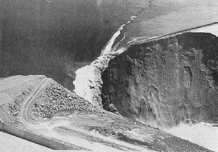
First Leak
U.S. Bureau of Reclamation photo
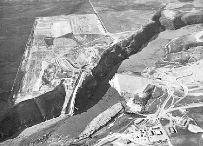
Dam Broke
Photo by Roger O. Porter for the Rexburg Standard
Journal
Evening
U.S. Bureau of Reclamation photo
The Teton Dam was located in Fremont County, Idaho, in the Teton River Canyon above Wilford. It was just completed in 1976. Workman and machinery were still available at the site. The reservoir was full from spring runoff with 260,000 acre feet of water. The site is still accessible but no longer maintained. To reach it go East on state highway 33 past Newdale and watch for the big historical marker near a road going off to the left. The dam site is at the end of the road.
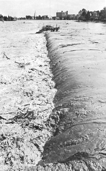
Water began seeping from the canyon wall about 750 feet down stream from the dam Thursday, but no alarm was sounded because some seepage is expected in an earthen dam.
By early Saturday, June 5th, a new leak had appeared near the abutment. The photo at right shows the beginning of the end. Note the pickup trucks atop the dam on the left for scale. By 9:30 a.m. this leak had begun. Four bulldozers were sent in to try and plug the leak. It continued to grow.
At 10:30 a.m. dispatchers at the Fremont and Madison Sheriff's offices were notified. Radio and television reporters raced to the scene and began broadcasting live, alerting most citizens to the problem.
Meanwhile area residents were already calling and going door to door warning families who lived just below the dam to get out fast. Around 11:00 a.m. a whirlpool was spotted in the water above the dam. By now the hole on the downstream side had grown to more than 25 feet in diameter. One of the bulldozers got stuck. Another moved in to pull the first out, and both were swallowed by the hole. The operators were pulled free with ropes that had been tied around their waists.
Suddenly the Western third of the dam disintegrated. One witness said the wall of water seemed to hang in the air for a second, then come crashing down the canyon.
An estimated 80 billion gallons of water was loose and headed for the Upper Snake River Valley.
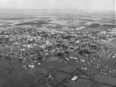
By evening, the reservoir had drained completely. The water in the valley below was still moving. It ripped through Wilford, rolled over Sugar City, and charged through Rexburg. When it reached the South Fork of the Snake River, the rush of water turned West and went around the Menan Buttes, washing through Roberts before turning South again.
This photo was taken that evening from an airplane on the northwest corner of Rexburg. The oval track near the bottom is the rodeo and fair grounds. The group of larger buildings on the opposite corner of town is the Ricks College campus which was spared for the most part because of its location on the hill. Many residents of Rexburg and Sugar City spent the rest of the summer in the college dorms.
Rexburg, evening
U.S. Bureau of Reclamation photo
Northern Rexburg
U.S. Bureau of Reclamation photo
taken Sunday
The falls at Idaho Falls
Photo by Loel Schoonover
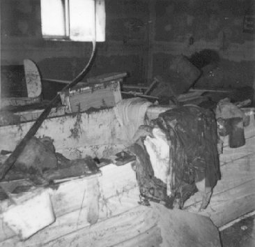
My Room
photo by Elaine Johnson
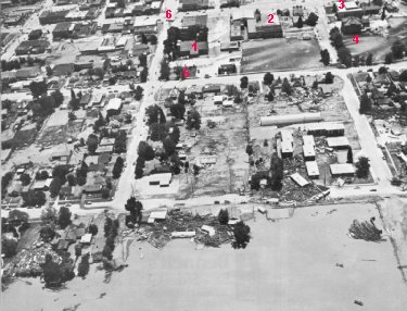
A picture of Northern Rexburg taken Sunday. The logs came from the
sawmill on the northern edge of town. They acted like battering rams
being pushed through town by the water.
1-Old Fremont State
Tabernacle. Currently site of the Teton Dam Flood Museum.
2-Formerly
Madison High School. By 1976 it was the Junior High School.
3-First
High School in Rexburg (excluding the Ricks Academy), later the Junior
High School, then Washington Elementary. It was torn down in 1997.
4-Original Washington Elementary building. Declared unsafe after the
flood, it was eventually torn down.
5-Current site of the Madison
District Library.
6-Intersection of Main & Center streets.
Idaho Falls had almost two days to get ready for the water. The Snake River runs right through town. The main concerns were businesses along the river and the safety of older bridges. Trenches were dug around the end of the Broadway Bridge to divert pressure. Dynamite was used to blast log jams that pushed against the bridge. Sand bags were piled along the water front. By the time the water arrived, there was little they could do besides watch and hope it was enough. The water fall itself almost disappeared under the muddy water.
By the time the water reached Blackfoot, the National Guard had been called in to help. The shopping center, located in a low spot next to the river, filled with water. A recreational lake and picnic area was damaged. A trailer park was flooded but most of the town was sparred. Out in the Pingree area, the ditches filled with water, but no damage was done.
The American Falls Dam was old and already holding back a vast amount of water. It stood between the flood waters and the rest of the Snake River Plain. Officials were concerned about its ability to hold the sudden rush of water coming at it and had begun releasing water immediately. In the end the American Falls Dam held, and the flood was over.
Cleanup would take the rest of the summer. Thousands of volunteers from the region, especially Utah, came in on buses to help. They boarded the bus early in the morning, worked all day, and rode home at night. Some came back day after day.
I was a teenager when the Teton Dam broke. This picture is my bedroom afterward. It was clean before, I swear.
The next door neighbors were out of town at the time. My dad broke into their house and turned the electricity off. The neighbor's house across the street just clipped the corner of our house as it went by and ended up a mile down stream.
That mud smelled really bad! We were directly down-flood from the stockyards, the rodeo grounds, the sawmill, and a fertilizer plant. A few days of June sun and the parts of the mess that used to be alive started to rot. Then the weather turned cold. The third Sunday in June, I saw snow in Rexburg. Everyone's hands were always wet trying to clean. My dad got the water pump working, but the water heater was trash so you had to wash in ice cold water. Our hands were so cold the bones ached. It stayed cold for most of a week.
It was very important to get the mud washed off of and out of things before it dried. The valley's soil has a high clay content and the Dam was made of material intended to harden and set. Once the mud dried it didn't want to go anywhere. If you wet it down, it would stink again.
[A poem, which appeared that summer in the Rexburg Standard Journal.]
nonymous
It was the fifth of June,
an early summer Upper Valley day.
I was workin' in the garden
and the kids were in the yard to play.
At 12 o'clock we all went in
and cleaned our shoes off by the door,
So as not to track the mud in
on the shiny kitchen floor.
Then the guy on the radio said,
"Believe me if you can,
"Because there's 80 billion gallons
headed for us from the Teton Dam!"
My hubby said, "We'll probably
get a little water in the basement, dear.
"But just in case it's worse than that
let's take the kids and get on out of here."
I told him, "Bring some diapers
and a baby bottle if you will."
And we loaded up the family car
and headed for the college hill.
We found out downtown Rexburg
was a crazy, panicked traffic jam.
'Cause there was 80 billion gallons
headed for us from the Teton Dam.
When we heard the water covered up
the steeple of the Wilford church,
We knew the folks in Sugar
would need to find a higher perch.
Then by three o'clock, the valley
was covered by a raging lake,
And all the cows in Hibbard
went surfin' on a twelve-foot wake.
And huge logs from the sawmill
tore through buildings like a battering ram.
The day that 80 billion gallons
were flushed out of the Teton Dam.
Well, our photos and pianos
are soaking in the smelly mud.
Our basement's full of water
and our garden's covered up with crud.
If we can find our houses
we clean them out for what they're worth.
They'll be scraping up the muddy mess
for years from here to Firth.
If I sound a little bitter,
it's for certain you can say I am.
Because right now the Upper Valley
isn't worth a Teton Dam.
Contributed by Elaine Johnson
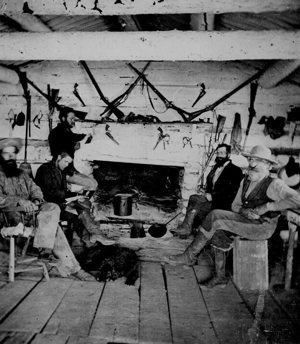 "Jackson took this interior of Sawtell's ranch house. Partners Sawtell and Wurtz
caught fish for sale to miners at Virginia City, Montana. They also rented
lodgings to big game hunters.
"Jackson took this interior of Sawtell's ranch house. Partners Sawtell and Wurtz
caught fish for sale to miners at Virginia City, Montana. They also rented
lodgings to big game hunters.
"Earliest to record the scenery of eastern
Idaho was undoubtedly William Henry Jackson, photographer with Ferdinand V.
Hayden's Geological Survey party of 1871-72 . . . Although most of Jackson's
pictures for the Hayden Survey recorded topography and geology, those of Fort
Hall Agency, Sawtell's Ranch and Taylor's Bridge, on the site of modern Idaho
Falls, have great historical interest. His photographs of Yellowstone are often
credited with persuading Congress to make it our first national park." - Arthur
A. Hart, "Camera Eye on Idaho, Pioneer Photography, 1863-1913"; The Caxton
Printers, Ltd., Caldwell, Idaho, 1990.
"In 1868, Gilman Sawtell started a
dude ranch and Henry's Lake Fishery that did much to develop this natural resort
area. Sawtell did everything from supplying swans for New York's Central Park
zoo to building a net work of roads for tourish access to Yellowstone National
Park. His commercial fishery served Montana mining markets. His pioneer Herny's
Lake ranch was a major attraction here for a decade before rail service brought
more settlers to this area." Sawtell's Ranch Highway Marker at
untraveledroad.com
Copyright © 1996- The USGenWeb® Project, IDGenWeb, Fremont County

This page was last updated
03/24/2025